April 2017
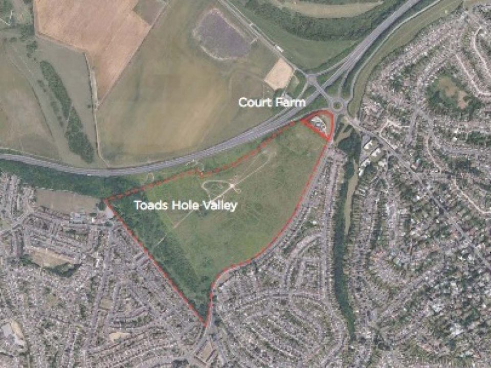
The Regency Society was broadly supportive of the first iteration of the Draft City Plan (City Plan Part 1). In particular the Society has supported the proposal, as set out in Section DA7 of the City Plan, to designate the area of land known as Toad’s Hole Valley for mixed use with a predominance of housing. Toad’s Hole Valley, it should be noted, is a triangular area of scrub-land with a gross area of 47 hectares that is bounded by the A27 by-pass and King George VI Avenue.
The Council has now issued a draft SPD for the site and has invited comments. Whilst the Regency Society supports the general objectives of DA7, it finds the draft SPD to be far from satisfactory.
At a general level, the SPD fails to offer specific guidance to developers – much of the document consist of vague homilies with which it would be hard to disagree but which are totally lacking specificity: much of it reads as if it has been cut and pasted from other documents. The SPD contains nothing that could be construed as a masterplan or an urban design study for the site. It avoids offering any concrete proposals for solving the traffic problems associated with George VI Avenue or for defining a strategy for accessing the site.
In drawing up the SPD the Council’s hands are clearly tied by the fact that it does not own the land and can therefore exercise only limited proscriptive control over how the present owners choose to develop it. The owners, already divided into several sub-owners, have recently sold a 50% share of the land to a development company. There seems to be nothing to prevent these separate owners from dividing the land into smaller parcels and developing it in autonomous stages over a number of years. Under these circumstances it would be difficult for the Council to force the owners to produce an overall master-plan for developing the whole site.
In lieu of a masterplan the SPD offers a schedule of land-use. After excluding Court Farm at the north-east corner and the strip of land along the south-western border which is designated as a ‘Site of Nature Conservation Interest’, the site is said to have a developable area of 37 hectares. The schedule allocates 5 hectares for education, 3.5-4.5 hectares for business, and 2.5 hectares for open space, leaving an area of 26 hectares for housing. It then specifies housing densities in a range from 50 to 75 dwellings per hectare. However, it sets a minimum target of only 700 dwellings which is equivalent to an average overall density of 27 dwellings per hectare (approximately 11 per acre).
Given the shortage of housing land within the City and the substantial house-building targets to which the Council is committed under the City Plan, this minimum target seems overly modest. If the 26 hectares were to be developed at the suggested range 50 to 75 dwellings per hectare the resultant totals would be between 1,300 dwellings and 1,950 dwellings.
On the other hand the SPD fails to take into account the loss of developable land that would result from the inherent difficulties of the site – it is steeply sloping, its northern and south-western boundaries are affected by traffic noise from the A.27, and it can only be accessed from the busy George VI Avenue. A more realistic estimate for the net area would be around 20 hectares.
But even 20 hectares, if developed with a mixture of housing forms, could support the development of far in excess of 700 units. If the range of target densities were to be extended from 50 dwellings per hectare (eg Stanford Estate) through 100 dwellings per hectare (eg the Hanover street grid ) to 150 dwellings per hectare (eg Furze Croft / Wick Hall), it would be feasible to set an overall minimal target of at least 1,500 dwellings.
An additional issue is the fact that the SPD ignores the fact that the main (only) route into Brighton from this site is down Dyke Road Avenue, which already suffers from serious traffic congestion at key times, leading to delays in public transport. George VI Avenue (A2038) goes to Portslade, the turn-offs at Goldstone Crescent and Nevill Road go to Hove.
The Regency Society urges the Council to consider developing a simple master plan for the development which, amongst other things, would set out an outline urban design strategy, identify possible improvements to George VI Avenue and define preferred points of access to the site. It also recommends that the target minimum dwelling total be raised to a figure compatible with such an outline urban design strategy.